CONTENT
To orientate oneself in space, one must first of all know in
which direction one is looking with regard to a known
reference.
The basic partition of the space around oneself is thus
based on the four sides instinctly felt and described in all
languages, in front and behind, left and right of the own body. This
defines a first partition of the circle in four parts (1/4).
Away from home, a possible reference may be the sun's position
during the day: rising (East), zenith (highest position) at noon
(South), setting (West). Although this
reference system varies during the day and the seasons, it is quite
reliable ... in sunny countries. The winds blowing always in
the same direction at the same time also constitute a reference
system. But the only never changing reference (in a
man's lifetime) is the
North star (in the Northern hemisphere).
One of mankind's
greatest achievements was to
realise that magnetized metal points to this star. From this
position, a circle around one's own position could be defined and the
other directional elements like the sun's positions were integrated
with precision in this circle. These form the basic
Cardinals.
The circle thus divided into four parts, each quarter can be halved
in its turn (1/8) and so on until we obtain sectors measuring 1/32
of the full circle. These are called
rhumbs.
The result
of this is what we call the
rose
of the winds.
It used to be beautifully drawn on early compasses and maps. If the
compass rose
is large enough, it is still possible to divide all divisions again by
two so that the precision is a 1/64th part of the circle. We will see
this number later again (see MILS below). However, the great difficulty
to
steer a boat on a moving sea makes such a precision unnecessary.
Furthermore, the circle can be divided into other units
resulting of mathematical calculations (see also the
traditional
Chinese
divisions). Concerning the division in 12 winds, read
The Riddle of the Compass
by A. D. Aczel (bibliography).
THE VARIOUS UNITS:
RHUMB, DEGREE, GRAD/GON, ANGULAR MIL
(Artillery)
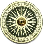
RHUMB
or POINT
This word with unclear etymology (does it come from "rhombus", the
form
of the arrows on the picture at right?) designates a subdivision of the
circle. The rose of the winds is divided into 32 points also called rhumbs,
each one being equal to
(360/32 =) 11° ¼ (15').
Each point was also divided into half- and quarter- points i.e. 128 in
the whole. Designating a steering direction in this system was
cumbersome and could lead to errors.
In the late 19th century, figures were first introduced to avoid
ambiguous designations (read in Wikipedia, The
points of
the compass, 4
- Half-
and quarter-points).
Picture
at right:
Ancient French compass rose, 18th C. - Click to
enlarge
Rear Admiral Wharton, Hydrographer of the Navy, issued as early as 1893
charts
featuring compass roses also graduated in degrees and Thomson (Lord
Kelvin)
patented his new compass card graduated in 360° on the rim.
Germany introduced the
360° compasses in 1941. |
 |
RHUMBS plus non
linear values
Some 16th c. maps depict a conventional rose featuring the usual
division in rumbs and
around them four scales with values as follows: (example) West and East
facing
a
zero (or two zeros for infinite), North and South facing 17½, and
inbetween the figures 18, 19, 21,
25,
31½, 46 and 88. These
figures are distances in "sea
miles" (1/20th of a degree, i.e. 3 nautical miles or 5.5 km)
that a ship must sail to cover a distance corresponding to 1° of
latitude depending on the angle between the ship's heading and the
equator. The lowest figure (17½)
corresponds thus to a course along a N-S axis, the highest (88)
represents the angle near an E-W-axis.
Such roses of the winds
are also described
in Les
premières oeuvres de Jacques Devaulx (Le Havre,
1583) by a French
cartographer (link
to the online French Bibliothèque Nationale
(GALLICA). A facsimile with explanations in English was
published under the title Nautical Works (ISBN 3836539233).
Pic. at r.: Denis de Rotis,
1674, Carte de l'Atlantique nord, source Gallica.

Picture
at left courtesy J. Eichhorn:
Ancient compass rose in Macao's airport - Click to
enlarge
|

|
The degree ist the most common division system of the circle.
It was first used by Ptolemy in his astronomy book called
Almagest. One degree is a 360th of the full circle. It is
related
with the number of days in one full solar year that can be observed by
the apparent movement of the sun above the horizon (365,25). The number
360 which was known in many early civilisations is
very useful in maths since it can be divided into 4 quadrants (right
angle). A particular type of division used during a long time
on
big
survey and on small pocket compasses was the quadrant. Each quarter of
the circle is numbered separately, starting with zero at North and
South. Directions (bearings) were read and noted with only a small
figure starting from the next cardinal and by indicating the sense.
Example: 190 degrees is thus said 10 deg.
SW.
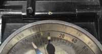
Picture
at right:
Ancient British pocket compass, c1850 - Click to enlarge
|
|
The grad is a unit of plane angle, equivalent to 1/400 of a full
circle, dividing a right angle in 100 parts. It is also known as gon,
grade
or gradian, gradient or radian. One grade equals 9/10 of a degree or
pi/200 of a radian*.
This is the application of the metric system on the division of the
circle defined in France at the time of the Revolution : this division
system was used for all geodesic measures of
France
(see examples like MERIDIAN or
STOPPANI in the category Survey Compasses). The gon was the official
measure unit in the French Army since September 11, 1921 (Bulletin
officiel).
In 1899, trials at sea conducted were onboard ships carrying metrical
compasses, maps etc. (see Revue
du Cercle Militaire, issue no. 21, p. 551 - 27 May 1889).
*
Read Wikipedia for more
details |
French Marching
compass Modèle 1922
with 400 gon divisions
Click
to enlarge |
French,
German and Austrian miner compasses featured a graduation in
24 hours or twice 12 hours
(with latin cardinals - link to
pic.) until the mid 19th century, later together
with a 360 deg. division (ex.: BREITHAUPT, ROSPINI,
ROST, STUDER. Pic.
at right:
drawing on page Pl. VI in
L'art
d'exploiter les mines de charbon de terre, MORAND,
1768,
with a description in French on the website of BnF/Gallica, read the
para. Platteau,
p. 213-214.
- Description of still older survey compasses in the book: Boussoles des mines des XVIe et XVIIe
siècles
(last paragr. on p. 620).
- Explanation: "The
hour (Latin.
hora) used to be the unit on
miners compasses. One hour being the 24th part of the circle (or a full
revolution of the Earth), it
equals (360/24) 15°. This
unit is divided into halves, quarters and so forth down to
1/16 (i.e. 96 units in a right angle). Relative precise
measurements could be done by using fractions. It has
disappeared on miners compasses but the graduation featuring twice 12
hrs is still in use on surveyors compasses*."
* Source:
Lehrbuch der Markscheidekunst (The science of mining), by Brathuhn,
German,
4th ed.,
Leipzig, 1908 |

A
miner's compass featuring a 2 x 12 hours division (ca. 1750)
Click
on the image for enlarged view. |
ANGULAR MILS
Read also a comprehensive explanation on the website
www.trademarklondon.com:
The
real Truth about Mil Dots.
(Definitions according to Wikipedia - for more details read the full
article)
The angular mil is commonly used by military organizations. Its
relationship to the radian gives rise to the handy property that an
object
of size
s
that subtends an angle
theta
angular mils is at a distance
d
= 1000 s / theta. Alternatively, if the distance is known, we can
determine the size of an object by s = theta d/1000. The practical form
of this that is easy to remember is: an object located 1 km away and
seen within angle of 1 mil measures about 1
meter (2 pi/6.4 = 0.98 m to be more precise). Another example: an
object situated in 2 km distance and seen within an angle
of 100
mils is 200 meters
long. Even on large compasses, the scales are only graduated in steps
of 10 mils. Marching compasses feature scales in 100 mils
(divisions: 0-64, see
pictures of examples below).
Comment: In the general case, where neither the distance nor the object
size is known, the formulae may be of little use. In practice, sizes of
observed objects are known with reasonable accuracy since they are
often people, buildings and vehicles. Using the formulae, distances of
the objects can be readily calculated without a calculator. In military
terms, distances are of course essential for artillery bombings and
estimations of journey times.
German
artillery compass (WWII)
Divisions: 6400 mils, every 10

Click
on pictures for
enlarged views
|
Conversion
table on the
rear side of a German light artillery compass
(see Survey/Art., letter X, no manufacturer indicated)

Columns (from l. to r.) :
- Grad G
/ % (= grade and percent)
- Strich — (=
MILS in German,
symbol: a long
dash as exponent)
- Grad ° (= degree) |
Marching
compass
Model 1922
(France, WWII)

|
Conversion table
of a
French
marching compass Model 1922 (modified version of Houlliot,
1933)

Abbr. (at the right end of the scales):
- "D" for degré
(degree)
- "G" for grade
(gon)
- "M" for millième
(Mils). |
The official symbol (at least in France) is the letter "m" with a bar
making an
angle of 30
degrees across it :

.
This letter "m" was chosen for the French word "millième"
(i.e. "thousandth"). In the angloamerican world, the word MILS ist used
(see the BRUNTON M2 compass in the category Survey Compasses).
On older German compasses and in their relevant documentation, the
symbol used was
an apostrophe (') or an horizontal bar placed as exponent. Example in
table above:
rear side
of a German artillery compass - unfortunately without maka er's name
(click on picture to enlarge).
 5760
5760
Older German artillery compasses featured a 5760 mils division (see
picture at right). This unit represents one 16th of a degree, i.e. a
degree divided by 2, the result then divided by 2 etc.: 4th, 8th,
16th. 360 x 16 = 5760.
Examples:
GOERZ and
ZEISS.
6000
The Soviet Union and Eastern European
countries (Warsaw pact) used the lower practical figure 6000. This is
the division 0-60 seen on Russian, Yugoslavian, Hungarian, Romanian,
Czech and Polish compasses. China, Vietnam and Arab countries also use
it. This division system was used by a French Artillery officer called
Emile Rimailho* for a gun type that he had developed in 1904
and
dubbed
155
CTR (
court
à tir
rapide
/ short barrel, fast shooting).
This gun was the ancestor of the anti-aircraft FLAK guns.
This unit is therefore sometimes called in France
"millième Rimailho".
*
French
officer and engineer
(born in Paris 1864, died 1954 in Pont-Erambourg,
département Calvados).
6300
The (neutral) country Sweden used until recently a
third system with 6300 MILS (
streck
in Swedish - ex.: Bézard, LYTH,
NIFE
and
SILVA).
During World War I,
the Swiss
BÜCHI
developed a
special version of its artillery aiming device called Sitometer
featuring a 6300 MILS division for Danmark's Army and called
it
Danish
division.
NOTE
-
Håkan Sahlin, Major
(retired) in the Swedish artillery sent us the following information : The
survey units are using
theodolites with gon (400 grades) divisions whereas the observers and
the fighting units used the swedish unit 'streck' (6300 mils).
6400
The mil being one thousandth of a radian, the exact figure
would thus be
6283.
The more practical figure used in the Western world (NATO) is
6400.
Such a precision is not achievable on hand-held compasses. The last two
digits are thus not indicated. This is the division one can
see on the
western military compasses (0-64). It used to be indicated
counterclockwise on older German Bézard compasses for
instance. Until 1933, the zero/6400 marking was at the South cardinal
point and 3200 at North.
Measurement of distances with
angular mils
The division in angular mils makes it possible to calculate a distance
even when no parameter is known.
Major Rudolf Gallinger serving in the imperial Austrian Army had
known very well the inventor Johann von Bézard during WW I
and he wrote in the years 1920-1930 several manuals for "tourists" (see
definition)
and soldiers. He described in them how to use this compass in order to
compute the distance of an object and the size of objects at a known
distance.

There are several methods:
- a) moving on a straight line in the direction of the target or away
from it
- b) moving sideways from line of sight to the target.
- Method a)
Assessing the distance between the present position
A
and a target
located in
c.
Measure first the angle built by two
representative points (
a
and
b)
located on either side of
c
(i.e.
s
= 91
mils in the figure above). Walk then towards
c
up to a point
B
located at a known distance of
A,
for instance 100m and which we call
Z and
measure from there again
the angle built by
the two points left and right of
c
(i.e.
s1
=
99.2 mils). The formula
is as follows:
To calculate the distance
X
(between
B
and
c),
multiply the value
Z
of
the move
(A-B = 100 m) by the angle
s
(91 mils) and divide the result by
the difference
d
between both angles (i.e.
s1
- s
= 8.2 mils.):
X = Z x s / d = 100 x 91 / 8.2 = 1100 m.
Add then the value of the first move from
A
to
B
(100m) to obtain
the distance
A-c
(1200m).
NOTE: It is also possible to go back from the observation point. One
must
then substract the moving distance.
- Method b)
In the present case only one additional point is necessary: it should
be situated 100 mils sideways of the line of sight (
A-B)
to the target.
One goes a certain distance in the direction of the additional aid
point and measure again the angle between
c
and the target.
With these
distance measures and angle values, one can calculate the distance to
the target with the same formula as with method a).
One can also estimate a distance without computing it. For instance the
broadth of a river. The method is as follows: One must draw hereto a
sketch with a certain scale. First, chose an easily recognizable object
on the opposite bank and take a bearing of it against the next cardinal
point. Move then sideways by a certain distance (100 m for instance),
at a 90 degrees angle and take again the bearing. The difference
between both is the angular value of the line B-C that is to be drawn
on the sketch. Since the distance A-B is known, one can measure on the
sketch the length of the line A-C at the cross point with B-C.
- Special devices in compass lids and tools
Some
compasses
have one or several rulers located besides the sighting slots in the
lid (picture right: TELEOPTIK M49 - click
to enlarge).
These compasses must be held at a certain distance from the eye, for
example 25 cm or 50 cm. To this purpose, the compass' lanyard has a
knot at the right place, that you can hold with one hand against your
cheek while holding the compass at eye's level with the other hand. The
size of the observed objects is also measured in mils.
 The Universal
Bézard-Kompass (UBK)
had an additional system:
attached to
the compass was a foldable ruler comprising two halves of 8 cm each,
i.e. 16 cm when fully open. The first 10 cm were also a division in
mils and read:
0-20-40-...-200-11-12...! The Universal
Bézard-Kompass (UBK)
had an additional system:
attached to
the compass was a foldable ruler comprising two halves of 8 cm each,
i.e. 16 cm when fully open. The first 10 cm were also a division in
mils and read:
0-20-40-...-200-11-12...! |
 |


